Skip to content
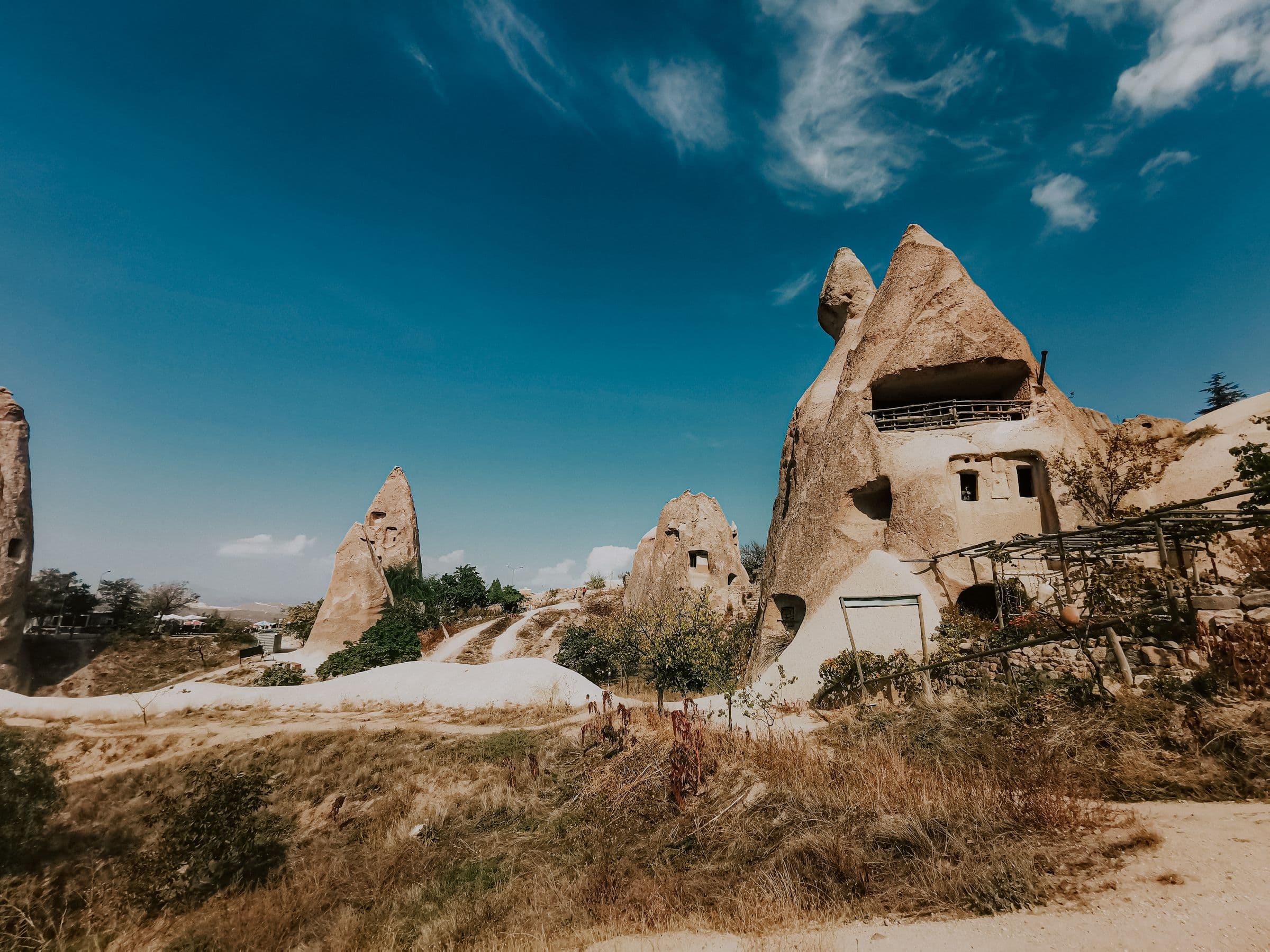
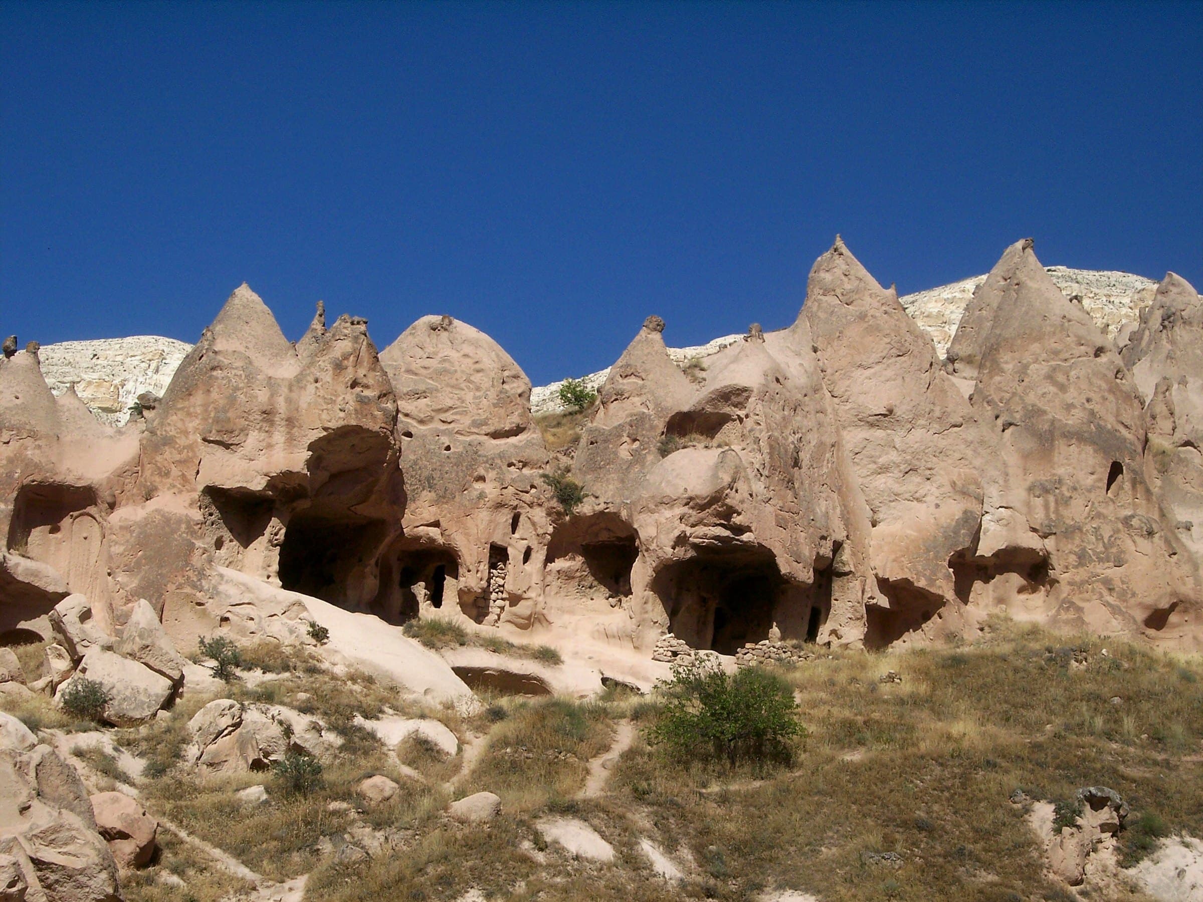
Dwellings cut into fairy chimneys at Göreme; doors and windows opened in the rock

Cappadocia · formation

This landscape has been under construction for ten million years

Ash, water and time built the valleys. Then people spent ten thousand years cutting into them. Here is how it happened, and where the research still argues.

Scroll: 15 million years

Middle Miocene · roughly 15 million years ago

01 / 11

First, a continent buckled

Africa and Arabia kept pushing north. Anatolia, caught in the squeeze, began sliding westward along great strike-slip faults. Beneath central Anatolia the crust thinned, and magma found its way up.

Volcanism began here in the Middle Miocene. The volcanic belt it produced runs roughly 300 kilometers from northeast to southwest, between the Tuz Gölü fault system on one side and the Ecemiş fault on the other. Everything else on this page happens inside that belt.

How the volcanic belt formedSchematic map, not to scale. Africa and Arabia push north; the Anatolian block slides west. Two fault zones cross in central Anatolia, and volcanoes appear along their intersection.Anatolian blockAfrica and Arabia push northslides westvolcanoes along the faults
Figure 1 — How the volcanic belt formed

Source note

The onset is given as a broad interval rather than a dated event. Published estimates range from about 20 to 13.5 million years, depending on which process is being dated: plate break-off, regional uplift or the first preserved eruption.
9.2 million years ago

02 / 11

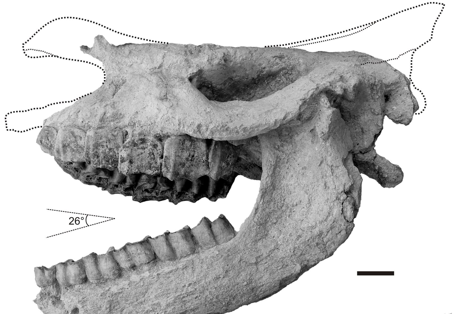
A rhinoceros inside the flow

The uppermost unit of the Kavak Ignimbrite, Kavak-4, settled 9.2 million years ago. Inside it, researchers found the skull of a rhinoceros.

The animal was not buried after it died. It was cooked: the pyroclastic flow carrying it was around 400 °C. This is the single best-dated moment in the whole Cappadocian sequence, and that is precisely why it is worth telling. Almost nothing else here is pinned down this cleanly.

The Karacaşar rhinoceros: Ceratotherium neumayri cranium and mandible, left lateral view
The skull that came out of Kavak-4, the best-dated moment in the stack · Antoine vd. 2012 · PLoS ONE · CC BY 4.0

Source note

Antoine et al. (2012), PLoS ONE 7(11):e49997, open access. The age itself comes from Aydar et al. (2012), Journal of Volcanology and Geothermal Research 213–214:83–97.

About 9 to 5 million years ago

03 / 11

Eight times over, and then some

The eruptions kept coming. Each pyroclastic flow spread across the plain and cooled into a sheet; the next one buried it. What geologists map today as the Ürgüp Formation is that pile: a calendar you can read down the side of a valley.

The units are listed below with the oldest at the bottom, the way they sit in the rock. Read the ages as approximations. This is not vagueness on our part: for most of these layers the published dates genuinely disagree, and the disagreements are marked where they matter.

About 5.2 million years ago

04 / 11

Kızılkaya: the umbrella

The Kızılkaya Ignimbrite is welded. Its glass shards were still hot enough, under the weight of everything above them, to fuse into a single mass. The result is far tougher than the soft tuff below, and it is the caprock sitting on the head of nearly every fairy chimney in the region.

As it cooled it contracted and cracked, in two dominant directions. Rainwater went in along those cracks. So the carving of this landscape did not begin on a flat surface; it began on a fracture network. The valleys are not arranged at random, and neither are the pillars.

Cooling cracks decide where the valleys goAbove: seen from the top, the welded cap is cut by two dominant sets of cooling joints that outline blocks. Below: in cross-section, rainwater enters along those cracks and widens them into gullies, deeper towards the right.From above: the fracture networkIn section: cracks become gullies
Figure 2 — Cooling cracks decide where the valleys go

About 2.5 million years ago

05 / 11

Erciyes has the last word

The youngest of the great sheets, erupted from the Erciyes system, caps the stack. It is dark, dense and glassy, and where it survives it forms the hardest surfaces in the region. After it, the story stops being about eruption and starts being about removal.

Source note

A naming caution worth carrying into other sources: the label “İncesu” has been applied to two different units. Pasquaré’s 1968 “İncesu member” was later renamed Kızılkaya, while other work uses “İncesu Ignimbrite” for this youngest sheet.

A calendar in the valley wall

The ignimbrite stack

Ages are rounded deliberately. For most of these units the published radiometric dates disagree with each other, sometimes by more than a million years, and quoting a single figure to two decimal places would suggest a precision the literature does not have. Where the disagreement is significant, it is marked.

Youngest unit on top, the way the eye reads a valley wallcompeting published values, click to open
  1. Kumtepe Ignimbrite

    Pleistocene

    The youngest sheet in the pile, and very thin: in places little more than a crust. Middle to Late Pleistocene; no precise radiometric age is in general circulation.

  2. Valibabatepe (İncesu) Ignimbrite

    ~2.5 million years

    Dark, dense and glassy, erupted from the Erciyes system. Where it survives it forms the hardest surfaces in the region.

    Disputed

    Published values cluster around 2.5 and 2.8 million years. Reported volumes conflict too, roughly 100 km³ in one study against 38 km³ of magma equivalent in another, largely because the two are measuring different quantities.

  3. Kızılkaya Ignimbrite

    ~5.2 million years

    Welded, brick-red to deep maroon, and the most consequential layer on this page: this is the caprock that holds up the fairy chimneys. Its cooling joints run in two dominant directions and set the pattern the valleys later followed.

  4. Gördeles Ignimbrite

    ~6.3 million years

    Warm honey-brown, flecked with gold mica. Finer at the base, coarser towards the top.

    Disputed

    Its age overlaps Tahar within error, and the nominal values make Gördeles the older of the two, which inverts the order mapped in the field. Radiometric dating cannot currently resolve which came first.

  5. Tahar Ignimbrite

    ~6.1 million years

    A patchy, heterogeneous gray-violet band carrying blocks of older rock.

    Disputed

    See Gördeles above: the two overlap within error and their order is unresolved. Earlier field-based work placed both considerably older, at 7.2 to 7.8 million years.

  6. Cemilköy Ignimbrite

    ~7.2 million years

    The thickest and palest band in the sequence: off-white to light gray, dense with pumice fragments.

    Disputed

    Two separate samples give about 7.2 and 6.7 million years, and a third value of roughly 7.4 also circulates. Whether these are different samples or different compilations is not clear from the published summaries.

  7. Sofular Ignimbrite

    ~8.2 million years

    A thin, intermittent pale band that appears and disappears along a valley wall. Easily overlooked, and often left out of popular accounts, but it does have a published radiometric age.

  8. Sarımadentepe Ignimbrite

    ~8.4 million years

    Thin but hard, dark red-brown, with a columnar jointing pattern. One of the first genuinely resistant caps in the sequence.

    Disputed

    Published ages run from 8.0–8.2 million years in the older K-Ar work up to 8.6 in later studies, with 8.4 the value most often carried forward.

  9. Zelve (Akdağ-Zelve) Ignimbrite

    ~9 million years

    Massive and unlaminated: a single gray-beige block sitting directly on Kavak.

    Disputed

    This unit carries the widest disagreement on the page. Published values include 9.9–9.1, 9.31–9.43, about 9.2, 8.5–9.0 and 7.6 million years: a spread of more than two million years across peer-reviewed sources using different methods.

  10. Kavak Ignimbrite (Kavak-1 to 4)

    ~9.2 million years

    The oldest unit in the pile, and one of the thickest: coarsely porous and flecked with pumice. Its uppermost sub-unit, Kavak-4, holds the rhinoceros skull and is the best-dated horizon in Cappadocia.

    Disputed

    The 9.2 million year figure is secure for Kavak-4 specifically. For the group as a whole, later work proposes a range of about 10.5 to 9.1 million years, while magnetostratigraphy places it at 9.3–9.4. K-Ar values from the 1970s carry uncertainties of ±2.5 million years and should never be quoted as precise.

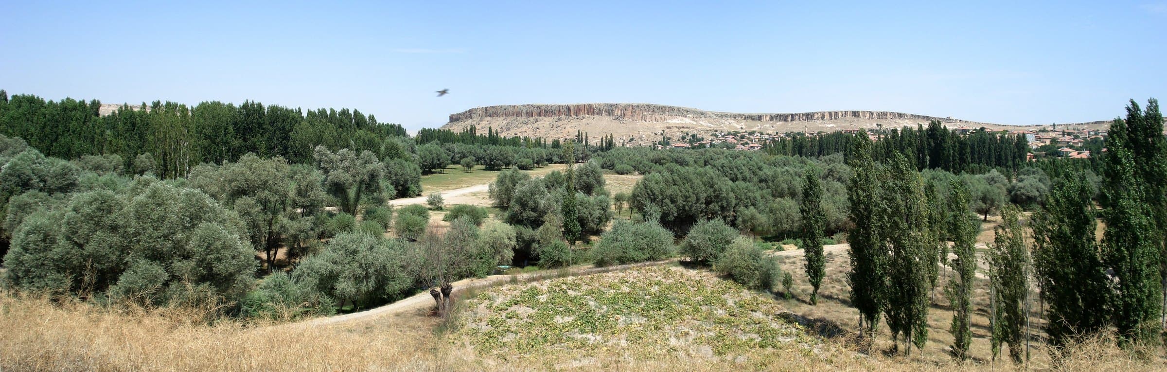
A valley wall at Zelve: eroded fairy chimneys and the pale caprock unit crowning the ridge
In the field: the same stack, on a real valley wallFoto: Noumenon · CC BY-SA 3.0 · Wikimedia Commons

The last two million years

06 / 11

Room to fall away

A fairy chimney needs slope and depth, and neither existed while the plateau was flat. As central Anatolia rose, the Kızılırmak and its tributaries cut down into it, and every step down steepened the walls above.

The river kept its own record: terraces standing 13, 20, 75 and 100 meters above the modern bed. Measured downcutting over roughly the last two million years works out to about five centimeters per thousand years, slow enough to be invisible in a lifetime and fast enough to hollow out a country.

The river cuts down and leaves terracesCross-section, not to scale. The plateau surface stays where it is while the river cuts down in steps, leaving a terrace shelf at each stage: 100, 75, 20 and 13 meters above the modern bed.Plateau surface100m75m20m13mTerraces left behindToday’s bed
Figure 3 — The river cuts down and leaves terraces

Happening right now

07 / 11

The life of a fairy chimney

A hard cap shelters the soft tuff directly beneath it from rain, while the unprotected slope alongside retreats far faster. A pillar is left standing. Nothing is carved out; everything around it is taken away.

Caps lose a few centimeters every thousand years. Eventually the neck thins until it can no longer carry the cap, and the cap falls. From that moment the cone is bare and erosion speeds up by roughly a factor of ten. In one valley you can see all four stages at once: forming, mature, decapitated, collapsing.

The four stages of a fairy chimneyFour stages side by side. A hard cap isolates a pillar, the pillar matures, the neck thins until the cap falls, and the bare cone then erodes far faster.FormingMatureDecapitatedCollapsing
  • capped: a few cm per 1,000 years
  • cap gone: roughly ten times faster
Figure 4 — The four stages of a fairy chimney

Source note

Erosion rates from cosmogenic ³⁶Cl measurements, Sarıkaya et al. (2015). Published summaries differ slightly on the exact figures; the order of magnitude is the point.

Why any of it could be carved

08 / 11

Stone you can cut with a hand tool

Unwelded tuff is extraordinarily porous. The gaps between glass shards and pumice fragments never closed. In engineering terms it is weak to very weak. That is a liability in a building stone and a gift to anyone holding a pick.

Near the surface, dissolved minerals precipitate back into the pores and form a thin, tougher crust over softer material within, which is why a room cut into a cliff face tends to hold. The same volcanism also produced obsidian at Göllüdağ and Nenezi Dağ; geochemical fingerprinting has traced that glass as far as Syria, the Levant and Cyprus. It was the region’s first export.

8400–7300 BC

09 / 11

A thousand years in one place

On the bank of the Melendiz river at Aşıklı Höyük there is an unbroken village sequence roughly a thousand years long, the earliest known settled community in central Anatolia.

You can watch the architecture change through it. The ninth millennium BC has oval, semi-subterranean mudbrick buildings; by the eighth, houses are rectangular, packed tightly together and entered through the roof. Excavation began in 1989 under Ufuk Esin and has been directed by Mihriban Özbaşaran since 2010.

The Melendiz valley from the top of Aşıklı Höyük; a columnar-jointed ignimbrite plateau on the horizon
Foto: Kvaestad · CC BY-SA 3.0 · Wikimedia Commons

Source note

Stiner, Özbaşaran & Duru (2021), Journal of Archaeological Research 30(4):497–543.

10th–11th centuries AD

10 / 11

Then the valleys emptied

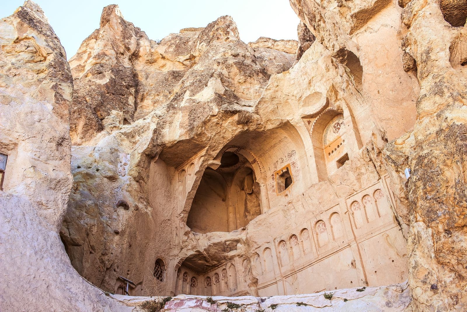
The overwhelming majority of the rock-cut churches still standing date to the Middle Byzantine period, and especially to the 10th and 11th centuries. The Old Church at Tokalı is placed around 913–920 on stylistic grounds; Karanlık and Elmalı belong to the middle of the 11th century.

That dating matters, because it contradicts the story usually told about this place. These are not first-century hiding places. They are the architecture of a settled, prosperous provincial society, cut at a time when its builders were neither persecuted nor cut off.

People went on living in rock-cut houses into the middle of the twentieth century. Zelve was evacuated in 1952 because of rockfall and reopened as a museum in 1967. In 1985, Göreme National Park and the Rock Sites of Cappadocia entered the UNESCO World Heritage list as a mixed site, inscribed on the cultural criteria (i), (iii) and (v) as well as the natural criterion (vii).

A church cut into tuff at Göreme: apse, blind arcading and decorative bands

Source note

Günay (2024), Valonia 1:35–63, DOI 10.5505/valonia.2024.43531; UNESCO World Heritage Centre, list entry 357.

Today

11 / 11

And at dawn, above all of it

Ten million years of stacked ash. A welded cap that decided where every pillar would stand. A river that made the room. Ten thousand years of people cutting shelter into stone soft enough to cut.

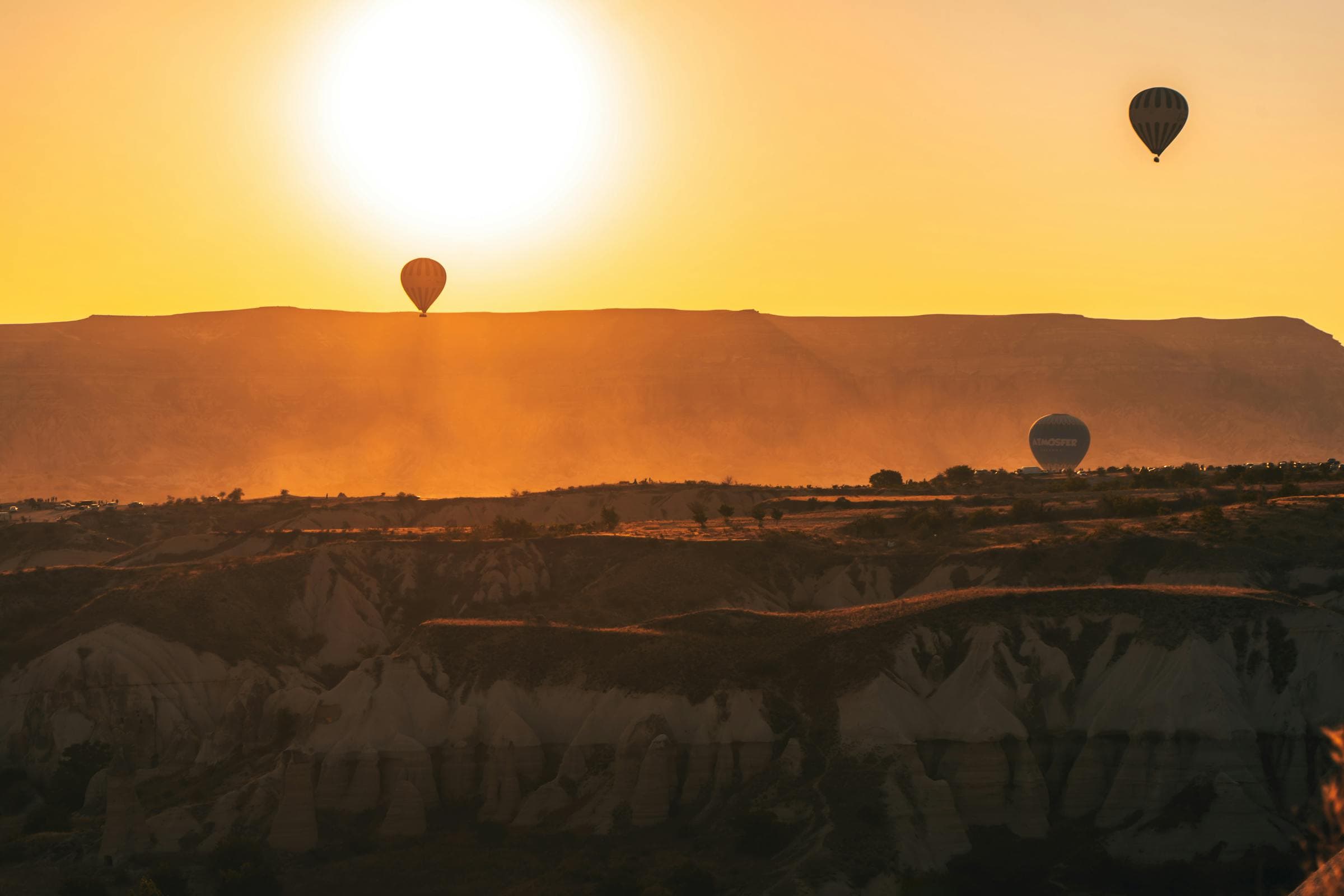
In 2024 there were 31,851 balloon launches across 236 flyable days. The landscape underneath them is still being taken apart, a few centimeters every thousand years.

Source note

Launch and flight-day figures for 2024 from the Turkish Directorate General of Civil Aviation (SHGM).

Hot air balloons over the Cappadocian valleys at sunrise

The same landscape today, in the real frame

The human record

What people did with it

  1. 20th–18th century BC

    Kültepe: Anatolia’s first archive

    At Kültepe near Kayseri (ancient Kaneš) an Assyrian merchant quarter, the karum, lay northeast of the main mound. Some 23,000 Old Assyrian cuneiform tablets have come out of it: credit, partnership, shipping, family letters. They are the earliest written documents from Anatolia.

  2. c. 520 BC

    The name is written down

    The oldest surviving record of the region’s name is the Old Persian Katpatuka, in the trilingual inscriptions of Darius I. Herodotos places its people in the third Persian tax district.

  3. AD 17

    Rome annexes the kingdom

    Archelaus, the last client king, was summoned to Rome, accused of preparing a revolt and died there. Tiberius annexed the kingdom outright, and Cappadocia became an imperial province.

  4. 4th century AD

    The Cappadocian Fathers

    Basil of Caesarea and the two Gregories shaped both Trinitarian theology and the Eastern monastic tradition. Basil’s own community, though, was in Pontos, not in the tuff valleys. The rock-cut churches came some five centuries later.

Fact check

Things you will read everywhere that are not true

These claims are repeated across guidebooks, tour pages and travel articles. None of them survives contact with the published research.

  • Cappadocia means “land of beautiful horses” in Persian.

    Folk etymology. Katpatuka is genuinely an Old Persian place name, and it appears in the Behistun inscription of Darius I around 520 BC, but the “beautiful horses” reading has no linguistic support. The leading scholarly proposal derives the name from Hittite katta peda-, “low country”. The region’s ancient reputation for horses is real; this etymology is not.

  • The underground cities were dug by the Hittites.

    No excavation-based evidence supports this. Hittite-period occupation in the region is documented on settlement mounds such as Ovaören and Kültepe, not in the rock-cut complexes. The dating of those complexes is described in the scholarly literature as genuinely uncertain, because carved space produces no real stratigraphy, only later fill.

  • Derinkuyu housed 20,000 people.

    No peer-reviewed source, calculation or population record supports this figure. It circulates by being copied from one popular article to the next. The academic reading is that these were temporary refuges used in a crisis by people who lived above ground, not permanently inhabited cities.

  • Xenophon describes Cappadocia’s underground cities in the Anabasis.

    The passage about underground dwellings (Anabasis IV.5) concerns Armenia, not Cappadocia. It is repeatedly misattributed in order to give the complexes a date around 400 BC.

  • The rock churches were carved by early Christians hiding from Rome.

    The overwhelming majority date to the 10th and 11th centuries, roughly seven hundred years after the persecutions ended. Textual evidence for the region thins out almost entirely after late antiquity and resumes with the Middle Byzantine building boom.

  • Göreme was a landscape of monasteries.

    This is the “monastic myth”, which grew out of 18th and 19th-century travel writing and has been steadily dismantled since 1985. In Robert Ousterhout’s survey of the Çanlı Kilise settlement, only one of twenty-three courtyard complexes proved to be a monastery. The rest were houses.

  • Cappadocia was listed by UNESCO for its natural beauty.

    It is a mixed site, inscribed in 1985 on three cultural criteria, (i), (iii) and (v), as well as the natural criterion (vii). Describing it as a natural listing hides half of what it was recognized for.

Where this comes from

Sources and method

Every date on this page comes from peer-reviewed publication, a UNESCO nomination file or an official statistical release. Where the literature disagrees, we say so rather than picking the most convenient number. Ages are deliberately rounded: quoting a radiometric date to two decimal places would imply a precision the field does not currently have.

  • Antoine, P.-O. et al. (2012). A Rhinocerotid Skull Cooked-to-Death in a 9.2 Ma-Old Ignimbrite Flow of Turkey. PLoS ONE 7(11):e49997. doi:10.1371/journal.pone.0049997
  • Aydar, E. et al. (2012). Correlation of ignimbrites in the central Anatolian volcanic province using zircon and plagioclase ages and zircon compositions. Journal of Volcanology and Geothermal Research 213–214:83–97. doi:10.1016/j.jvolgeores.2011.11.005
  • Lepetit, P. et al. (2014). Geochemistry 74(3):471–488. doi:10.1016/j.chemer.2014.05.001
  • Piper, J.D.A. et al. (2013). Journal of Volcanology and Geothermal Research 262:47–67. doi:10.1016/j.jvolgeores.2013.06.008
  • Le Pennec, J.-L. et al. (2005). Journal of Volcanology and Geothermal Research 141(1–2):45–64. doi:10.1016/j.jvolgeores.2004.09.004
  • Akın, L. et al. (2021). Zircon geochronology and O-Hf isotopes of Cappadocian ignimbrites. Gondwana Research. doi:10.1016/j.gr.2020.12.003
  • Sarıkaya, M.A. et al. (2015). Cosmogenic ³⁶Cl erosion rates for Cappadocian fairy chimneys and slopes.
  • Stiner, M.C., Özbaşaran, M. & Duru, G. (2021). Aşıklı Höyük: The Generative Evolution of a Central Anatolian PPN Settlement in Regional Context. Journal of Archaeological Research 30(4):497–543.
  • Günay, G. (2024). Byzantine Rock-Cut Architecture in Cappadocia and Beyond: The State of Scholarship. Valonia 1:35–63. doi:10.5505/valonia.2024.43531
  • Ousterhout, R. Survey of the Çanlı Kilise settlement, the basis for dismantling the “monastic myth”.
  • Barjamovic, G. A Historical Geography of Anatolia in the Old Assyrian Colony Period.
  • Encyclopaedia Iranica, entries “CAPPADOCIA” and “KATPATUKA”.
  • UNESCO World Heritage Centre. Göreme National Park and the Rock Sites of Cappadocia (list entry 357, inscribed 1985, mixed site, criteria i, iii, v, vii).
  • Directorate General of Civil Aviation (SHGM), Republic of Türkiye. 2024 balloon flight statistics.
How Cappadocia was formed · field pageBack to sources ↑